With my 5e/ACKS mashup coming in less than a week, I've been taking a lot of the side work I've been doing the last couple of weeks and getting it all together for Session 1. Setting notes, NPCs, towns, people, monsters... I have quite the treasure trove of stuff ready for this game. While I've played 5e, I have only ever run it once, so I haven't gotten into creating my own races and such yet. Still want to get my sea legs with the current ruleset before I start creating. But I imagine it won't take too long.
Below is the Atlas sized map for South Western Thivola, the continent inspired by South America.
This map in particular is inspired by the Chilean-Argentinean area where Santiago is. The north western part becomes a desert due to the coastline mountain range blocking the trade winds and due to it getting ever so closer to those Horse Latitudes. Further north, there is a plateau similar to the Altiplano. I plan on having a variety of deserts up there. The barren wastelands, the dried up lake turned salt flat, and some sandy dunes. The mountain range is Etapu's Spine, named after the people's founder god of the earth and forests, Etapu. I plan on widening it some more as it goes more south. On the other side of it in the north lie the beginnings of sub tropical wet forest. Further north and east, I'll probably put in some more rain forests and swamps.
As you get more south, the terrain, climate, and vegetation changes to be more green and hilly. The mountains get closer to the coast. The climate becomes more temperate with Mediterranean summers. More rivers and some swamps here and there. This is where the players will be starting their adventures. On the other side of Etapu's Spine, I plan on widening the mountain range to be about 200 mi wide. Very much a montane/alpine area. Then, it will lead to a more arid, steppe-like area of nomadic tribes and such before hitting the coast on the other end.
From here, I have a great variety of terrains and climates that will make exploration and travel interesting to the players. While they will be starting in something a bit more familiar, they can end up in some deserts, rainforests, alpine, or even tundra. All in a geographically close area.
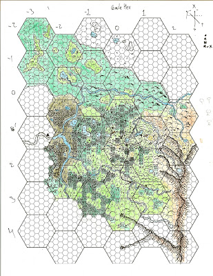
I do have more zoomed in maps for campaign use. I have a Regional Map with small 6-mile hexes that create large 24-mile hexes. I also have a Provincial Map with small 1-mile hexes that create a large 6-mile hex. And finally, I have the Local Map, which just focuses on a single 6 mile hex broken up into 43 1-mile hexes and half/third hexes. Below is a mostly finished Provincial Map. The players will be starting in the large triangle.
 |
| I'm bad at coloring within the lines |
You can see that from the center to the upper left, my style of drawing changed drastically. I went from doing more symbolic mapping to more iconic mapping. I may redo this at a later point to keep the style consistent and to use a hex map that isn't so dark.
While this campaign is using 5e for the basic rules, I've been using ACKS for a lot of the nation building. You'll notice in the Atlas map that there are some pencil marks that encircle certain areas of the map. These are provinces of the empire ruling over the northern area. The cities are the capital holdings of the nobles in charge of these provinces, built up by ACKS's empire building rules. It was pretty interesting putting the rules to work. Setting up populations and big cities and the empire's metropolis capital in the mountains. The players will be adventuring on the frontier area, away from a lot of these big cities. However, with enough travel time and horses, they can get to one of the capitals in four days. Great if they want to buy and sell expensive stuff, or want more urban adventuring and a break from the wilderness.
I'll get more into detail with the mapping and campaign as the week goes by. Till then, let me know what you think about the maps.

No comments:
Post a Comment